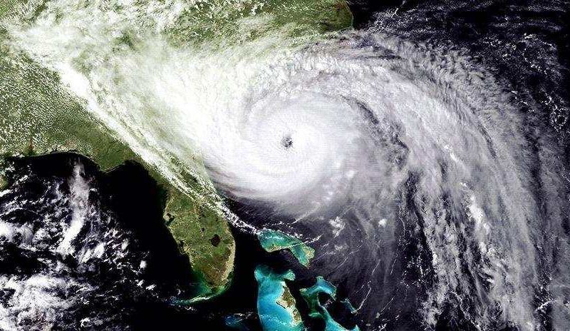
Around midnight on September 21, 1989, a category 4 storm named Hurricane Hugo struck the Lowcountry coastline near Charleston, raging ashore with lashing rain and sustained winds of 135 miles an hour.
The Charleston peninsula barely dodged a direct hit from the towering tidal surge, which reached a maximum height of 20 feet and ravaged the tiny coastal hamlet of McClellanville just to the north up Highway 17. Torrential rains, battering winds and a tidal surge combined to wreak havoc on Charleston and its suburbs.
Iconic images captured from the first responder evacuation of Sullivan’s Island showed the Ben Sawyer Bridge spinning around like a top, a powerful reminder of nature’s fury. When the storm abated the bridge resembled a super slide jutting out of the water.
Before barreling into the Southeastern U.S., Hugo devastated islands in the Caribbean, including the U.S. Virgin Islands and Puerto Rico, and after making landfall near Charleston it maintained hurricane force wind gusts nearly 200 miles inland, causing extensive damage in the Piedmont and foothills of the Carolinas as well.
All told Hugo caused 86 deaths and upwards of $8 to $10 billion in damage (adjusted for today’s dollars) according to the National Weather Service.
When the storm passed, the extent of destruction was evident everywhere. On the islands, roads and bridges had collapsed, power lines were wrapped in downed trees, propane tanks littered the streets and there was no drinking water. Most residences and businesses had suffered moderate to severe damage, including one home on the Isle of Palms that had been swept off its foundations and dropped into the middle of the street. A 12-foot storm surge wiped out nearly all oceanfront single family homes on Folly Beach.
Charleston peninsula homes suffered major flooding damage and nearly 80 percent of roofs in the city sustained damage.
Mount Pleasant looked like a bomb had gone off, with damaged structures, snapped pines, uprooted live oaks and downed power lines triggered by the heavy winds.
In McClellanville, which suffered the worst of the tidal surge, homes and businesses were destroyed and the wall of water had carried boats from the marshes and deposited them onto the highway. People who sought refuge in the Lincoln High School hurricane shelter barely escaped with their lives when the storm surge flooded the room and they were forced to climb to the rafters to stay above the rising waters.
Recovery
The recovery process from Hugo was long and required a sustained community effort. The islands took nearly five years to fully recover and tourism began to slowly rebound after about two years. The coastal seafood industry and the logging industry suffered major hits as well.
Much has been learned since Hugo and many adjustments have been made in emergency planning, including that hurricane shelters are no longer located in areas that would be vulnerable to a storm surge—as was the case for Lincoln High School. All shelters are now located in the northern end of the county, according to the Charleston County Emergency Management Department.
Emergency officials now have access to better forecasting models so there are more accurate predictions of landfall, which means more precious time to prepare.
We have been fortunate to avoid the worst of recent storms like Dorian, Florence and Matthew, but you never know when the next Hugo will hit. That is why it is always important to be prepared. The South Carolina Emergency Management Division offers a hurricane preparedness guide that you can download at: https://scemd.org/stay-informed/publications/hurricane-guide/ containing essential information for residents, businesses and visitors.
When it comes to hurricanes, let Hugo serve as a lesson that we should always prepare for the worst and hope for the best.
Sources: https://www.weather.gov/ilm/hurricanehugo, Charleston County Emergency Management Department, South Carolina Emergency Management Division


